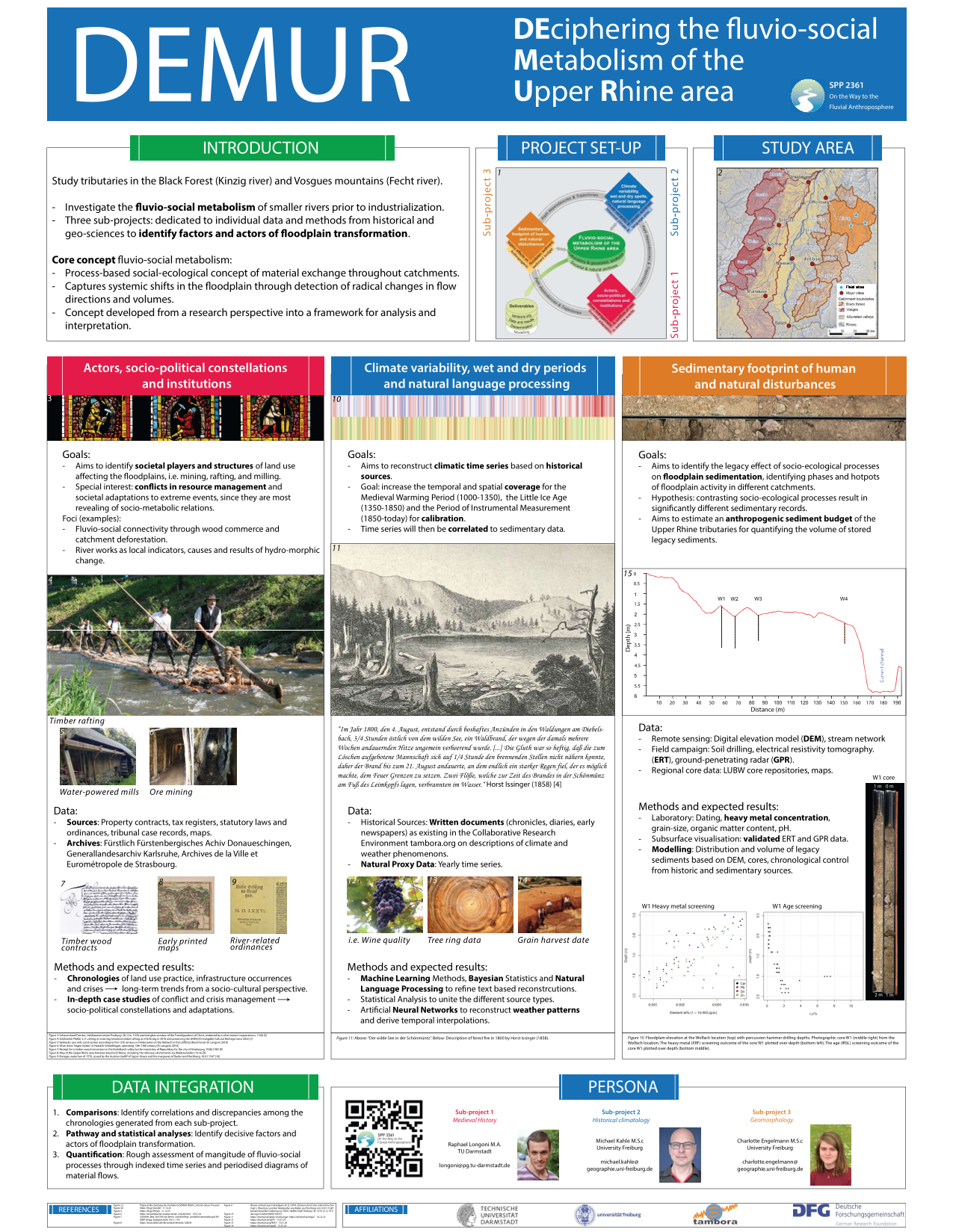
Deciphering the Fluvio-Social Metabolism of the Upper Rhine area (DEMUR)
Factors and actors in the transformation towards a Fluvial Anthroposphere prior to the industrial period
PIs: J.H. Blöthe, R. Glaser und F. Preusser, Universität Freiburg; G.J. Schenk, TU Darmstadt
The pre-industrial floodplains of rivers in Central Europe served a multitude of socio-economic interests ranging from coppicing and riverbank protection to industrial use for processing raw materials, powering mills and fishing as well as traffic. Little is known about their contribution to the long-term dynamics of floodplains prior to 1800. But their increasing occurrence since c. 800 CE suggests an environmental impact that led to a transformation from a near-wild state conditioned mainly by natural processes to a state where these processes were heavily modified by human activity. Hypothetically, this created a Fluvial Anthroposphere, which is the overarching research object of the DFG Priority Programme 2316.
The DEMUR project investigates this development in the Upper Rhine area by focusing on selected tributary catchments in the Black Forest and the Vosges mountains, e.g. the Kinzig and the Fecht. This collaboration between the Albert-Ludwigs-Universität Freiburg and the Technical University of Darmstadt uses the social-ecological concept of the Fluvio-Social Metabolism as a heuristic tool to trace floodplain dynamics via decisive changes in material flow patterns of e.g. water, sediment loads, timber and ore within the catchment by assessing their impact on the floodplain. As a multi-disciplinary endeavor humanities and geo-sciences are combined in a three-pronged approach:
Sub-project 1 identifies actors, socio-political constellations and institutions of floodplain-related land use through analysis of written archives. The main focus is on conflicts in resources governance between stakeholders, e.g. millers, rafting associations and sovereigns, and on societal reactions to extreme events, e.g. hydraulic flood protection, and economic trends. Sub-project 2 identifies regional wet and dry spells based on the historical-climatological data base tambora. Trend reconstruction is improved via statistics and natural language processing and will disclose external climatic factors with influence on the floodplain. Sub-project 3 determines the sedimentary footprint of human and natural disturbances through core analysis of floodplain sediments. The goal is to discern anthropogenic contributions via sediment budgets which changed e.g. due to deforestation upstream, and via legacy sediments, e.g. from ore mining and smelting.
In order to integrate the results, indications of land use and land cover change gained and gathered from sub-projects 1 and 3 are compared to each other and to climatic trends obtained from sub-project 2. As a synthesis path dependencies, trajectories and turning points in metabolic flows are approached via semi-quantification methods and statistical modeling, in order to determine long-term floodplain dynamics under human influence.